Tuesday, October 29, 2013

Non-Hike to the Huntington Library and Gardens

Well, this isn't a hike in the normal sense of the word, and I'm not counting it as such. But I did spend Sunday morning walking around the Huntington Library.
"The Hunting-ton" is in San Marino, although a lot of travel guides will insist it's in Pasadena. I've been a member for about two years, and have visited as a tourist about twice.
I've also visited it a few times as a volunteer, as they've had a couple of star parties there. It's a pretty large area, so, while far from dark, it's darker at night there than most parks, so I've actually had a lot of fun there.
Yet, because of my member-ship, I was feeling like I ought to go visit before the end of the year. So, with my Sunday recreation time budget limited (having done a major star part at Mount Wilson the night before), I figured a short walk around the gardens would be fine.

Trails crisscross the gardens, and I'm sure one could cover 4 miles by walking all of the trails. In my case, I'm going to guess I walked about two miles.
From the entrance, I walked through the Conservancy, then through the Chinese Garden, then above and around the Japanese Garden, then through some of the Australian plants, then the Desert garden. Then I came back across the main entrance, passing many statues along the way.

The Huntington has many art works and historical artifacts and manuscripts in its collection, but I usually come just to walk around the gardens. They're a great mixture of plants, and often have something in bloom or something changing color.
Of course, it being southern California, there's not a huge amount of fall color. The Japanese maples were still red, except for the ones whose leaves had burned. It's really too dry for those maples to do well here, unless you're able to shield them from afternoon sun.
There were also the ginko trees, which were somewhat yellow, but not colorful enough to make the final cut of photos here.

Lots of waterfalls, too. I'm not sure if maybe a few have been added in the Japanese garden section during the recent renovation.
The running water, refelcting pools, statuary near pools, and exotic plants make this a pretty relaxing place to be. Except, it being a public area, some members of the public are quieter than others. My time in the Zen garden was disturbed by a family of pre-teens, running around, shouting, and playing tag.

Yes, it's outdoors. And they're kids. But, really, in a Zen garden, you couldn't ask your kids to keep it down for a while?

My one reward for putting up with the screaming, running kids, was, about ten or fifteen minutes after the Zen garden, the were quieter and further away as I made my way past the giant bamboo.
And the inadvertently posed for a "forced perspective" shot. That's the picture two up, with the little kids waiting near a sign for their parents to catch up.

Of course, in the picture, you can't tell they're little kids, so they make the bamboo look taller and the path look longer than it actually is.

Spent about two hours walking around before heading back. Took something like 150 pictures in that time. Only a relative handful are here.
It's a great place to visit. Unfortunately, their hours are somewhat limited. For "normal" folks, it's 10:30am - 4:30pm. In the summer time, that's like four hours of daylight on either side of opening or closing that is "wasted."

Elite membership levels get to come in earlier.

Because of the limited hours, it's a little hard to get soft morning or evening light to photograph the park. And not a lot of backlighting, unless you're there as winter approaches, and the sun stays low.
>As a result, I was actually kind of psyched when I woke up on Sunday to a thick fog around my house. The fog was mostly burned off by the time the Huntington opened, but there was still enough moisture in the air to soften the light. That, and the low sun of late fall helped, I think.
I was really pleased with the results of this trip, and want to return again. The problem is that this will prevent me from going on a "real" hike. So we shall see.

In the meantime, I'm halfway through another busy work week. Haven't made firm plans for the weekend, at least not past Friday. I would like to take a longer hike, but I've got work-related stuff that might keep me from getting far in those plan.

Saturday, October 19, 2013

Hike 2013.027 -- Barber Peak Loop, Mojave National Preserve, CA

Hiked Friday, May 10, 2013. Yeah, this was a long time ago. However, the fall Mojave National Preserve Conservancy service trip and star party is fast approaching. With the federal budget standoff temporarily settled and partial shutdown over, I'll be heading out this way again, soon.

The star party is Saturday, October 26, at the Black Canyon Equestrian and Group Campground. Amateur astronomers from the Old Town Sidewalk Astronomers (myself, included) will be there with their telescopes a that evening, following the Conservancy's service work elsewhere in the Preserve.

Directly across Black Canyon Road from the group campground is the Hole in the Wall visitor center and campground. And, adjacent to the visitor center, is a trailhead for the Barber Peak loop and Rings trail.

In addition to hiking it in May 2013 (this write-up), I also hiked it at least twice before: In October 2010 (part of my original 100 hikes in a year) and October 2012. Could have sworn I also hiked this after one of our spring star parties before, but none popped up in a search of my previous hikes. It's likely I hiked it before I started my hiking blog, since we've been doing bi-annual star parties (and the Conservancy has been doing bi-annual service trips) for at least five years.

Because it's a loop trail, you can walk it either clockwise or counterclockwise. The previous times I've been here, I went counterclockwise. Just to give it a little variety, I decided to do it clockwise this time around. Oddly enough, I often notice how different things look coming than going, so I figured hiking "backwards" would let me see this hike in a different light.

The main difference I noted (and the reason why I think doing clockwise is backwards) is that the signage is not as good if you go clockwise. I lost the trail a few times going this way, which never happened when going couunterclockwise.

A second difference is that going clockwise means heading *down* Banshee Canyon and the rings at the start of the hike, rather than coming up the rings at the end of the hike. That may make a difference if you're more comfortable climbing up rather than down.

The final difference for this hike was that it was spring, and there are more flowers in the spring than in the fall. As it turned out, even in May, it was a week or so early for the Cholla cactus.

After exiting Banshee Canyon, the trail heads to the right (west), and begins its circum-navigation of Barber Peak. Because, afterall, this trail is called the Barber Peak Loop, not the Barber Peak trail. You walk *around* the peak; you do not climb it.

Following the west segment, then, your trail will turn to the north. After a short ascent, you pass through a gate that is used to divide grazing allotments. Descending the other side of this ridge, you'll soon be walking along the sandy bottom of a wash for most of the northerly segment. You'll also pass a nice outcropping called the Opelite Cliffs.

Since I've photo-graphed that outcropp-ing so many times on previous trips, it turns out I didn't bother taking any pictures of it on this trip. But you can see it on my previous Barber Peak Loop trail posts. Instead, all I have is this butte, the right side of which I think looks a little like an Elvis profile. (That's the butte two pictures up--the picture one up from here is the same butte from the other side).

Meanwhile, north of the previously-mentioned Opalite Cliffs, the trail splits. Bearing right (east) obviously continues the loop.

Going left, meanwhile, would take you to Mid-Hills Campground. I think I may try taking that route next time, just to see some different territory. I don't expect the scenery will be much different from what I've seen on the Barber Peak Loop, or my hikes to Table Top Mountain (also done twice, in April 2011 and May 2013. In fact, the Mid-Hills trail would pretty much parallel Black Canyon Road as you head north. Along the way, you'd pass Table Top Mountain, well to your east. Hence, walking the Mid-Hills trail really would be just to cover some new trail miles, without adding much in the way of new views.

The other two places I may try hiking in the Preserve would be Kelso Dunes, and the Lava Tube.

I was briefly at Kelso Dunes once before. I'd like to take a longer hike there. The problem is that I'd love to be there in the morning or evening, but the geography of where I will be and where the Dunes are make that impractical.

Meanwhile, the problem with the Lava Tubes is that a high clearance vehicle is recommended. So I'd either have to drive very slowly with my non-high clearance vehicle, or I'd have to walk quite some distance just to get to the "trailhead."

Another place in the area I'd like to visit Providence Mountains State Park. It's actually quite close to Hole in the Wall. The problem is that this particular state park has been closed for quite some time, ever since the state's own budget crisis, and remains closed "until further notice."

The other thing about hiking in the Mojave Preserve is that there just aren't very many developed hikes that are accessible by passenger vehicle. The only other one (besides those already mentioned) that I can access, I've also done several times Teutonia Peak.

At any rate, the Barber Peak Loop is about six miles around, with relatively modest altitude changes. The only complicating factor is the Rings section, where you will need some level of agility and/or strength to climb or descend the rings in Banshee Canyon.

Saturday, October 12, 2013

Hike 2013.047 -- Sloan Canyon National Conservation Area --Trails 100, 200 and 300

Hiked Friday, September 27. This is a repeat of my Hike 2013.013, from March. And, yes, I'm posting out of order. I do that, sometimes. :D

[Edit in addition to the trailhead information noted in the post linked above, please see this more updated post for trailhead access directions as of November 2014]

Drove out from Los Angeles on a Friday morning, arriving in the Las Vegas area in early afternoon. I considered several possible hikes on the way here, but eventually settled on this one. It's sort of the equivalent of Echo Mountain back in the L.A. area, in the sense that it is the closest interesting hike to my LV apartment base. It's pretty much on the way into Henderson from the south, so it's got essentially a zero drive time. And it's got a nice payoff, despite the short distance.

The payoff, of course, is the plethora of petroglyphs in a very short section of Sloan Canyon. Who knows why the local indigenous population picked one canyon over another, but they did. It's only about a 100 yard section where most are located.

[Note -- In the years since I wrote this, there has been a lot of development in the area. It's now paved all the way to the "new" visitor contact station, as tagged below, under "location."]

Getting to the trailhead is probably the toughest part of the hike. As noted on the hike I linked above, the official, BLM-approved route takes you over a long and extremely rough dirt road. The unofficial route requires only a short drive over a well-graded dirt and gravel road, with an optional additional mile over a rough road that is no rougher (but much shorter than) the rest of the official BLM-endorsed route. If you have a high clearance vehicle, it's a piece of cake. Otherwise, you just have an extra mile (each way) to walk.

This being almost exactly six months after my previous visit, the tempera-ture was not all that different. It was pleasantly cool. There were even some flowers, from the then-recent summer monsoon season. There were also a lot of what look like annual grasses, which are probably non-native, and the reason why desert wildfires have become so common where once they were unheard of.

From my "above the wash" parking location, I walked west maybe 1/4 of a mile to the unobtru-sively signed Sloan Canyon Road. Then I headed north, walking a jeep trail on which I saw only one car coming out during my entire walk. After about 1/2 mile, I noticed a a fair number of these rather large yellow worms. They had little horns on their butts, and they weren't true worms, because they had feet. I don't know what they were eating, where they were going, and what they would turn into after their metamorphosis, but there were a number of them inching across the road.

After maybe another 1/4 mile or so, past the sign welcoming you into the NCA and past the wilderness boundary, is a series of obstructions to keep cars from going further. There'a a kiosk display there with some info about the area. There was also a metal container holding a register. I signed in, on the assumption that visitation numbers might eventually lead to an improvement in monitoring and interpretation at this site. From there, it's an obvious walk along the wash bottom. That path is designated "Trail 100."

It's mostly volcanic rocks along the way, with desert varnish on the rocks that provide the "paper" for these ancient etchings. Some etchings look familiar, similar to what I have seen at other petroglyph sites. I've been to a number of such sites. The ones linked in this post are just the ones I've visited since getting a digital camera.

There are a couple of dry "waterfalls" along this walk. I suppose on very rare occasions, there would be water running through these canyons. However the presence of largish mesquite trees in the wash suggests that powerful waterflows are pretty rare.

Nonethe-less, there are a few class two or maybe class three segments where a little dexterity, and/or reasonable size and strength would be required. You don't have to be a great climber, nor necessarily young, but you will need to go up and/or down those short climbs.

Well, you don't *have* to go up and down, as there's a "backway" to the petro-glyphs. That's taking Trail 200 and looping around and descending Trail 100. That way is probably six times the distance, however. But combining Trails 100 and 200 does make a nice loop.

Trail 200 also takes you near an impressive volcanic plug, and provides a nice view both farther into the McCulloch Mountains and back into the Las Vegas Valley. Also, because it's a loop, you don't need to retrace as many steps. Somehow, that always seems like a plus.

It being somewhat cool, I saw a bit of wildlife this time: A number of birds, none of which stayed still long enough to be photographed, a California King Snake (that was just sprawled across the wash bottom as I approached, though he moved when he detected me), a chuckwalla, who lumbered into the shaded nooks as I approached (That's him, right of center, in the fourth picture of this post); lots of little lizards, some butterflies, and the aforementioned "worms."

Good hiking weather. About 4.5 miles walking for the day. As a reminder, please do not touch, climb over, etch on, or try to take or move the ancient petroglyphs. They are irreplaceable cultural artifacts, and easily damaged by the oils in your hands or the lug soles of your boots.

Saturday, October 5, 2013

Hike 2013.049: Aspen Grove and Santa Ana River Trail

Hiked Saturday, October 5. A full-scale post would take too long, so I'll do a short one, instead.

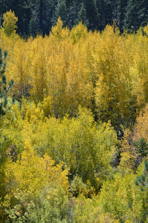
Anyone planning on a trip to the Aspen Grove this year, just wanted to let you know we're around peak color, now. Many of the leaves still have a hint of green, but other trees have already dropped their leaves. I'd say you ought to aim for a visit during the next one to ten days.
In addition to the aspen, oak and willow are also changing color nicely. Nothing quite matches aspen for their yellowness, but both are much more widespread. Along the streams, willow often form the foreground, with aspen in the background. Conifers, of course, provide another, darker contrast with the changing colors of the deciduous trees.
I began this hike right near where Forest Road 1N05 splits off from Road 1N02. In the little triangular area where the two road split is a small parking area. Immediately across the dirt road that is 1N05 from this parking area is a trail head, which is probably the westernmost section of the hiking section of Trail 2E03, the Santa Ana River Trail. Officially, it appears the Santa Ana River Trail is claimed to start about four miles east, where Forest Road 1N02 intersects with the Pacific Crest Trail.

According to the Tom Harrison map, it's about 3/4 of a mile on the Santa Ana River Trail before it intersects with a trail that heads towards the Aspen Grove Trailhead. From the intersection, it's a steep additional 3/4 of a mile. The trail intersects with Road 1N05 maybe 150 yards from the parking area, so there's a short segment of dirt road you need to walk.

From the parking area, it's about 1/4 mile to the crossing of Fish Creek, which is the boundary for the San Gorgonio Wilderness Area, and where the upper section of the Aspen Grove is located.

Once across Fish Creek, the Fish Creek trail heads north (left), and would quickly exit the aspen grove. This is the path I took last month.

However, if you turn right, you are heading downstream, and the aspen grove is thicker this way, and you get a nice backlighting that makes the leaves really pop.

In the past, I only took this trail a 100 yards or so, to get a good view of this grove. Today, however, I continued south. Although the Tom Harrison map only shows a short segment of foot path, in real-life, the trail continues south for at least several miles, apparently running all the way down to Highway 38. (The woman I ran into heading up this trail as I was heading down reported she had started out across the highway from the Wild Horse trailhead. It also turns out that there are several other aspen groves this way, spread out over what seems to be another mile or so.

The woman i chatted with also noted that she had seen a trail branching off this one, and headed up a hill, to the east. I was pretty sure that one would be the one I wanted, and it turned out I was correct. After a brief and steep climb, this trail was again heading back towards my car.

Since some of the trails I walked are not on the trail, my distance traveled is somewhat uncertain. Seemed to take about six hours, but I don't think I went anywhere close to ten miles. I did take over 200 pictures, so it's possible I was simply walking really slow. So maybe as little as 7 miles?

Very nice hike, and very colorful. It was a good day.