Thursday, April 26, 2012

The End of National Park Week

National Park Week runs through Sunday, April 29. Free entry into national parks, in case that last little bit of money is all that's standing between you and a trip to someplace really cool.

Normally, during fee-free national park days, fees are also waived at other federal lands requiring a visitor's fee. However, I have not come across any press releases about this week being free in the areas covered by the Adventure Pass. Moot point for me, since I have an Adventure Pass, though it expires at the end of the month. I'll have to try to get a day or two more use out of it before having to face my near-yearly dilemma of "America the Beautiful Pass or Adventure Pass?"

Tuesday, April 24, 2012

Hike 2012.025 -- Pathfinder Park to Schabarum Park

Hiked Monday, April 23. I didn't actually hike to the heart of Schabarum Park, but a more accurate description would take too many words.

After going eight days without an actual hike (had some stuff I had to do between Thursday and Sunday), I decided Monday was a MUST hike day. I was considering Chino Hills State Park, but I called during my lunch hour and found out the park was closed. I was surprised the slight drizzle of earlier in the day was enough to shut them down, but then had to pick an alternative. My choice was to try to see if the Schabarum trail went any further east than it appeared (I have previously taken it as far east as Fullerton Road and Pathfinder Road).

Near as I can tell, it does not. I turned east on Pathfinder and went several miles without finding any obvious spur of the trail away from Pathfinder and into the hills. Having no desire to walk along the road for multiple miles, I decided to park in Pathfinder Park and see if there were any trails heading directly out of the park.

I concluded that there was not. A road that does head into the hills is behind a locked gate, with a "No Trespassing" sign out front.

There is a 6/10ths of a mile trail around this park, which is what I walked in search of a longer trail. When none was found, I headed down from the top tier of the park to the lower area, then back west on Pathfinder.

Right at the corner of Pathfinder and Fullerton Road/Harbor Blvd, there is what may or may not be a parking area for horse trailers. There was no "No Parking" sign there, but neither was there an obvious sign encouraging parking or announcing this as a formal trailhead. That's why I ended up parking back at Pathfinder Park.

To get to the trailhead, take the Pomona Freeway (CA-60) to Fullerton Road. Go south on Fullerton just about two miles, to Pathfinder Road. I made a left turn at Pathfinder, and turned eventually went into the park entrance, about 1/3 of a mile from the corner. However, if you are interested in hiking, there are also several alternate parking locations off of Fullerton Road, with several alternate trail access points.

As noted in a previous post, Fullerton Road makes a quiet fork to the northwest, just south of Pathfinder. If you're not really paying attention, you'll like "stay" on the road you were on, and suddenly discover you're on Harbor Blvd, instead. The parking areas I mention above would be reached by turning on to this little Fullerton Road and looking to your right for the green Puente Hills Landfill Native Habitat Authority signs.

Most of the walking I did on Monday would be on the trail map linked here. At the far right end of the map, where the trail intersects with Fullerton, is near where I started. Pathfinder Road is not on that map. The name change from Fullerton to Harbor is also not on the map.

From Pathfinder Park, I headed down to the lower tier of the park, then west on Pathfinder, to my "real" trailhead for the day.

The trail is labeled on the map as "Schabarum Trail Extension." It begins literally behind a brick wall, with a sign that warns of mountain lions. I suspect that's just a "CYA" issue, though of course there's always the possibility of mountain lions in a quasi-wilderness area. The Puente Hills are supposed to be a wildlife corridor from the Santa Ana Mountains to the San Gabriel River, so a cougar could find this place, though he/she would have to jump plenty of fences and probably cross at least a few busy roads to get here.

After a brisk climb that puts you above the backyards of folks in Rowland Heights, you keep climbing and trending to the west. Your views are largely confined to the north, however, as you never really reach a ridge to see to the south.

After 2.7 miles, you intersect the Powder Canyon trail. This is after about a mile's worth of switchbacking descent. If I didn't know I had an alternate way back, I'd have been very reluctant to give away all that altitude (400-500 feet, I would estimate).

A right turn at the junction would keep you on the Schabarum Trail Extension, and lead you into Schabarum Park. Or, if I were feeling more ambitious and it were earlier, I could head right, then catch the Schabarum Trail westbound and make a very large loop of the day. However, this was an after work hike and I was not dressed to make a serious exertion very comfortable. So, instead, I made a left turn at the bottom of the hill, along a broad dirt road that was, nonetheless, not signed or labeled at the junction.

Because of my previous hikes in the area, I knew this would lead me towards Powder Canyon, where I could get back to Fullerton Road, then back to my car.

After 4/10ths of a mile up a fair incline, I reached the junction with the Purple Sage Trail. That's the way I had gone on a previous hike, though I have to admit it did look very different and somewhat unfamiliar when viewed from the opposite direction.

Two-tenths of a mile later, the Black Walnut Trail split off to my left. This would have been a very slightly longer distance, but I also knew it would entail another substantial altitude gain. Again, not being dressed for serious hiking, I declined the challenge. Instead, I stay on the Powder Canyon trail, which was broad and with no further altitude gains between me and Fullerton Road.

From here, things did look very familiar as I sped down towards my car. The map says it's 1/2 mile to the horse exercise area and parking lot, then 12/100ths of a mile from there to the Nogales trail, then a similar distance to narrow Fullerton Road.

It's probably another 1/10th of a mile on narrow Fullerton Road until you reach Harbor/Fullerton Road, then another 10th or so of a mile north on Harbor/Fullerton to Pathfinder. Then it's about 1/3 of a mile up Pathfinder to the park, and about 1/2 mile for me from the park up the hill, then along the circular walking trail that I followed around the ballfields before looping back to my car.

That means about 4.1 miles for my loop from the corner of Pathfinder and Fullerton and back again, 1/2 mile looping around Pathfinder Park, and about 1/2 mile each way between the park and my trailhead, for slightly over 5 miles for the day.

Plenty of mustard and radish are still blooming, though there are probably more seed pods than flowers on the radish. Thistle are still growing. Ladybugs were common on the thistle. I saw one "woolly bugger" on a piece of grass early on my hike. I also saw some lupine, a scattering of morning glory, a moth mullein, and a few other species I didn't know.

Monday, April 16, 2012

Hike 2012.024 -- Smith Mountain

Largely the same hike as 2012.022 from last week. The major differences were: 1) there was a lot more snow on the mountains to the north, 2) Getting to the top of Smith Mountain is much easier than it looks, and much easier than getting to the ridge on the opposite side of Smith Saddle.

Hiked Sunday, April 15.

Quite a change from last week. The cooler weather and lack of an Easter holiday mean far fewer picnickers packing the parking area at West Fork. On the other hand, about a million motorcycle and bicycle riders were out in San Gabriel Canyon on Sunday. I had to follow a train of about 30 of them up most of the mountain. I also got to hear their rumble from way up at the top of the mountain. Oh, joy.

Arrived at the trailhead about 15 minutes earlier than last week. Unlike last week, when my car was the first there, there were already about ten vehicles in the lot when I arrived (not counting the 30 or so motorcyclist who were parked at the south end and chatting amongst themselves.

One of the vehicles was a full-sized van, with Korean lettering on the side. Wasn't sure how many people came in that, but I knew there'd be company out on the trail.

Grabbed my stuff, headed out on the trail, and walked about five minutes up before realizing I forgot to hang my Adventure Pass on my rear view mirror. Hiked back down and hung the permit, then started all over again.

This first part is pretty steep, with full sun exposure. I got warm quickly, and welcomed the shade that I reached after turning into Lost Canyon.

Eventually passed the same patch of desert poppies I saw last week. Because of the cool night, the flowers were all closed up. They weren't nearly as impressive that way, although, by the time I got back, it was warm, the flowers were open, and they were again quite striking.

There was also a bit more water at the two points where water crosses the trail. Still nothing that a decent stride can't cross, but there was more. Also, I could hear a much louder sound of rushing water down below.

Reached the saddle about 50 minutes after my second start of the hike. As I noted last time, although the sign says it's three miles to the wilderness boundary, I think it's a bit less than that.

The going from here to the top of Smith Mountain is pretty steep, but definitely easier and shorter than my walk last week, heading south from the saddle. The way here is rockier and has more vegetation holding the soil up (north facing, I guess). The rocks holds the soil better and gives you solid foot holds or hand holds as you climb. The trail is also better-defined, with a bit of a weave pattern that makes the altitude gain easier than you might think. Also, the mountain is not actually as steep as it appears.

As I approached the top, I looked repeatedly to the north. The fire break route up to the ridge that I followed last week was easy to see. It was also clear as I reached the summit of Smith Mountain that, yes, I was correct last week: The ridge on the north of the saddle is definitely higher than Smith Mountain.

Nonetheless, the combination of being on a peak rather than a ridge and the snow cover over the high country meant the view was much more impressive from here than from there.

Twin Peaks, Bear Creek canyon, and Mt. Wilson are all off to the west. The Crystal Lake basin is off to the north, with Windy Gap being the obviously low point in the semi-circle of mountains that way. Hawkins is to the northeast, with a snowy ridge sweeping from north to northeast. As the ridge drops a bit to the northeast, Mt. Baldy peeks over at you.

At my feet, the summit of Smith Mountain was broad enough to accommo-date the roughly ten people who were at the top when I got there. A few very small patches of snow were still visible here, but definitely no more than would make a dozen or so snow cones. ;D

You can also see back down towards the parking lot where your hike started. It looks like a long way back. Still, I'm calling it 7 miles for the day.

Obviously more crowded than last week, but far from being crowded. There was only one point where I was annoyed by someone resting with his group, sitting down and eating lunch essentially on the trail. I had to move down a steep section of trail awkwardly to avoid the possibility of pushing dirt or rock down the trail and on to the slightly clueless hiker.

Saturday, April 14, 2012

Hike 2012.023 -- Bailey Canyon Falls and Rubio Canyon to Sam Merrill Trail

Two short and separate hikes today (Saturday, April 14), accumulating to what I figure to be a bit over 3 miles, so I'm counting them as Hike 23 for the year.

No pictures, so I'll keep the post brief and link to other hikes for trailhead information. I was sure I saw my camera in my trunk before I left this morning, but it was not there when I got to the trailhead.

Bailey Canyon Falls is almost always dry, but I figured with the two significant rains in three days, there was a chance water would be flowing over the falls.

Here's a link to my post when the falls were really running. Today, it was just a trickle. My garden host could generate more water than that. ;D Nonetheless, it *was* running.

After this short hike, I headed down to Santa Anita racetrack, paid my $2.75, picked up my "free" beer stein, cashed my $10.60 winning ticket from the Santa Anita Derby (hit a $1 exacta), then headed over to Rubio Canyon.

A picture of the switchbacks that mark the start of the trail out of Rubio Canyon is included as the third picture on this post.

The trailhead I used today is at the junction of Rubio Ridge and Rubio Vista Drive. There are metal containers with photocopied trail maps at the trail head and about 100 yards in from the trailhead.

After hiking maybe 1/10th of a mile, you reach the switchbacks mentioned above. They'll be on your left. I climbed the switchbacks, which were steep, but also among the most well-defined section of the trail today. After the switchbacks, you trail becomes narrow and even steeper, without nearly as much engineering as the lowest stretches. It's easy enough to follow, but it's definitely steep and it'll wear you out pretty quick.

I followed the trail as it began heading up along and towards a ridge. After what was probably less than 1/2 mile (but seemed longer), I heard voices and saw hikers on an obvious trail well above me. Turned out they were on the Sam Merrill.

Just before this ridge trail reaches Sma Merrill, several dead branches were tossed to obscure the trail some what. Stepping over, around, and through the downed branches, I popped out on the trail, about 100 yards before the electrical transmission towers that I consider to be the halfway point between Lake Avenue and Echo Mountain.

I walked under the towers, then turned around and returned the way I came.

On the return, I saw another set of switchbacks that seemed to be heading out of someone's backyard and also headed towards Sam Merrill. Don't know how far that one goes.

Meanwhile, back on the Rubio Canyon side of things, from the perspective of this ridge trail, the SCE right of way trail (an overgrown dirt road) was obvious, sweeping on up the mountain on the other side. The Camp Huntington trails that head up either towards the SCE road or further to the north were also obvious.

Wednesday, April 11, 2012

Hike 2012.022 -- San Gabriel Canyon to Smith Saddle and North to Jeep Trail

Hiked Sunday, April 8.

Initially planned on hiking to Smith Mountain. But when I got to the saddle, Smith Mountain looked too steep and far to do in the time allotted. Turns out the thing I actually did was longer and had more vertical gain.

From the Foothill Freeway (I-210), exit north on Azusa, drive through old downtown Azusa, pass some residential areas, and about 15 miles to mike marker 32 on Azusa Canyon Road. There's a "30 mph Zone Ahead" sign just before this parking area, and there's a portapotty and informational bulletin board here.

The drive to the trailhead, which I arrived at around 10am, was somewhat slow. The number of cars parked along the road, especially at the San Gabriel River's West Fork confluence with the North Fork, was already looking ridiculous. Folks were wheeling their ice chests and assorted other picnic supplies towards the West Fork road (closed to traffic, but open to bikes, horses, hikers, and picnicers with their rolling ice chests), where they would presumably continue east to find a picturesque spot, and eat. A disappointingly large proportion of these picnicers seem unable to cary out what they bring in, however. The West Fork after a warm weekend is really a sad sight.

Fortunately, once I got a mile or so past the West Fork, the cars thinnned out, and soon it was just me. The trailhead lot was empty. Oh, sure, I could still hear the rumble of motorcycles and tweaker econo-boxes, but the density was pleasantly low.

So I began my hike.

The sign at the trailhead says its 3 miles to the San Gabriel Wilderness boundary, which is at Smith Saddle.

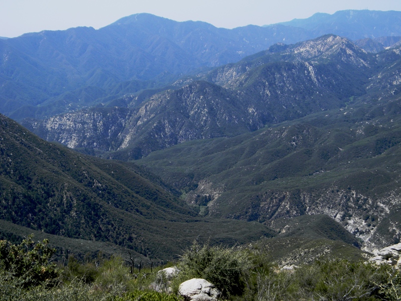
This trail begins by heading more or less southerly, gaining altitude as it works its way along the canyon wall. Eventually, the trail curves west, into a canyon (Lost Canyon) and runs along the perimeter of several side canyons as it makes its leisurely trip towards Smith Saddle.

Views of Smith Mountain greet you almost as soon as you start your hike, and you can see the saddle for most of the way towards that target. Smith Mountain and Saddle both appear deceptively close, because your round-about route adds substantially to the line-of-sight distance. By line of sight, it's probably only a bit over a mile from the first trail view. To keep your distance travelled in perspective, there are stakes at one mile intervals to measure your progress.

The views looking back at where you came are as pretty as the ones looking forward. Looking down Lost Canyon, or the San Gabriel River Canyon, or across and beyond the San Gabriel River Canyon towards Mt. Baldy, or up the Canyon are all pretty views.

During one of my looks back, across Lost Canyon, I saw a couple of fellow hikers, probably a mile behind me. Don't know when they started walking, but obviously it was some time after me.

I also came across a small patch of desert poppies. They're like California poppies, only more yellow. They were an unexpectedly large splash of yellow on the hillside near the trail. Just before the patch, I saw a single poppy, and thought it looked lonely. Didn't realize he had friends right down the trail.

Despite the 3 mile indication to the San Gabriel Wilderness that is posted at the start of the trail, it seems somewhat less than one mile after you pass the 2 mile marker that you reach Smith Saddle. There's a place to tie up your horse, if you had one.

The remains of an old fire break run both north and south from here. South (left) would take you up Smith Mountain. North (right) heads up the opposing slope. Incidentally, continuing straight would drop you into Bear Creek canyon. There's a trail that continues along Bear Creek all the way to the West Fork of the San Gabriel River. It is clearly possible, since, just before I reached the saddle, I ran into two hikers heading the other way. They had started the previous day from the West Fork Trail head.

However, my own effort (once from the north and once from the south) to link the two ends of Bear Creek's trail were unsuccessful; I lost the trail both times, probably half a mile before they should have met. Indeed, the hikers I chatted with here told me that following the trail was difficult, and it required multiple stream crossings. I didn't ask, but I suspect not all of those stream crossings end with your feet dry, even with the water level low.

In any event, back to our saddle. The trail towards Smith Mountain looked uncomfortably steep and far given the time I had to hike on Sunday. So I foolishly decided to see where the firebreak heading north would take me.

Well, it's not *really* foolish to explore like this. It was only in retrospect that I determined that hiking to Smith Mountain would probably have been quicker and easier than the route I took.

How do I know going the other way would have been quicker? More about that, later.

In the meantime, I started heading north. In some places, the way was level, but most of the way was very steep, up a slope that had very little traction. I'm figuring it took me at least half an hour to make it up to the final ridge level.

Once there, I encountered a weather station and a jeep trail.

Yeah, it turns out the ridge jeep trail would run pretty much due north, hitting the CA-39 just over a mile away. It appeared this would be right after the turn towards Crystal Lake, so I'm pretty sure I've even parked my car at what would be the other end of this jeep trail. It was obviously double track, so this trail gets at least some use by the folks maintaining the weather station.

More nice views from up here. The high, rocky, and steep walls that surround Crystal Lake were to my north. Twin Peaks was to the west, and the San Gabriel Canyon and opposing mountains were on the east. To the south was still Smith Mountain, though it seemed clear to me I was now higher than Smith Mountain.

I turned around and headed back towards the saddle. Seemed to take at least 20 minutes to get back, so I'm figuring on about 3/4 of a mile up this steep fire break.

Just before I got back to the saddle, I heard the voices of several hikers, and saw them, just below. I assumed they saw me, but apparently not. Once back on the trail back towards my car, I caught up to the two hikers within about five minutes. They were moving pretty quick, but not quite as quickly as me (because I was running late and needed to get back to town, stop at a grocery store, buy some food, and cook a dish for a family gathering later that afternoon).

Judging by the yellowish brown, broad-brimmed hat the taller of the two women was wearing, I'm pretty sure these were the same two hikers I saw about a mile behind me on my way up to Smith Saddle. Depending on how much resting they took on the way up, they probably got to Smith Saddle between 15 and 30 minutes after me. (I did not see anyone reach Smith Saddle as I made my way up the other way, although obviously I was spending more time facing away from the saddle than towards it--but I still spent a fair amount of time huffing and puffing and resting and looking back as I climbed).

Despite my head start, they got back to the saddle about 5 minutes before I did. So I conclude that I could have gotten to the top of Smith Mountain and back faster than I got to the ridge top I selected and back.

Hiked briskly back down the trail, passing one additional hiker as I did. That made exactly five hikers I crossed paths with during my 4+ hours on the trail. Also ran into about a half-dozen more at the trailhead. There were a number of other cars at the trailhead, so I don't know when they got there or where they went, but they did not cross my path.

As I neared the highway, I looked down the canyon and saw several patches of purple. The mountain lilac trees are in full bloom.

I'm estimating I'd estimate at least 7 miles for the day, which wasn't bad.

Saturday, April 7, 2012

Hike 2012.021 -- Sturtevant Falls

Hiked Tuesday, April 3.

The parking lot at Chantry Flats fills early on the weekends, so I haven't hiked here in a while. But when I got off work on Tuesday afternoon, I figured it now stayed light long enough for me drive all the way up to Chantry Flat, squeeze in a short hike to Sturtevant Falls, then get back to the car with time to spare. Only question remaining was if the lot would be full when I got there.

As I drove up the road to Chantry Flats (Foothill Freeway, I-210, exit Santa Anita Avenue, head north, into the mountains), there were essentially no other cars heading up. I started feeling pretty good about my chances of finding a parking spot. And, sure enough, when I got there, the lots were mostly empty. This was just about 5pm.

Walked briskly down the asphalt road that is the beginning of the Sturtevant Trail. Looking back up from where I came, I saw an unexpected splash of color, with many of the trees looking more like fall than spring.

About 1/4 mile down, there's a bend in the road where a nice little (8-10 foot or so) waterfall is set in a small alcove of the canyon. Very little water was crossing the road here, however, and the a peek into the alcove confirmed that little water was coming in on this side canyon.

I continued down the trail.

After another 1/4 mile or so later, the trail reaches the canyon bottom, right where the water from Winter Creek comes in from the left. The water coming out of Winter Creek was also not particularly high. I concluded that Sturtevant would look fine, but would not be roaring.

Somewhat surprisingly, I then came across a couple with fly rods. The gentleman said there were rainbow trout in there, though most were very small. He insisted he saw a few larger ones, however.

As I made my way up Sturtevant Canyon, I passed the numerous cabins that are set among the trees here. Periwinkle and ivy dominate the under story here. Whether because of the windstorm late last year or simple concern over the upcoming fire season, the area around these cabins seemed a lot more open than it used to.

Never saw any fish in here myself, though I have seen fingerling-sized fish in nearby Fish Canyon. That one's got a heavier flow than Santa Anita Canyon, so I'm less surprised by fish there than I am by fish here.

Not many flowers during this walk. Some white ones that I've seen here before, but whose name I do not recall.

I did come across a nice bush of Canterbury bell. Didn't notice them on the way down, but they were very noticeable on the way back up.

Came to Fiddler's Crossing and continued up canyon. Several folks were coming back from the falls.

Unexpectedly, when I got to the falls themselves, I had them more or less to myself. A few stupid people were climbing on the hill to the left, where numerous signs say not to climb. I'm not sure if they started from the top or the bottom, but they were slowly making their way back down towards the falls for most of the time I was there. So other than their occasional shouts, there was nothing but the sound of running water to keep me company.

I shot a lot of pictures of these very picturesque falls. I liked the ones where the lower falls are framed by a nearby tree (at the top of this post), though I also took some from straight away. Exposure times in the late afternoon shade were as long as 1/8th of a second. I shot some braced against a rock.

Seemed like about 10 minutes before anyone else got there, which was my cue to leave. I passed about ten more folks coming to the falls within the first five minutes after turning around.

I saw the fishing couple down below, as well. They were fishing in one of the deeper pools below a check dam. I watched a few moments, mentally critiquing the casting technique of one of them, and saw no fish hook ups.

On the way back up, I saw the gibbous moon, climbing over the edge of Big Santa Anita Canyon. I took many shots of that, too. For several, I braced the camera on a rock, as my exposure times were creeping up towards 1/10th of a second, which is way long when you're zoomed in. Pictures came out okay.

About four miles for the day. Nice to know there's enough daylight after work to successfully squeeze in a waterfall hike.

Friday, April 6, 2012

HIke 2012.020 -- Rubio Canyon

Hiked Sunday, April 1.

With the brief but significant downpour over Saturday night, I thought a waterfall hike on Sunday might work out well. Thought about Bailey Canyon, but settled on Rubio Canyon, instead.

Managed to find the trail head without making any wrong turns. Took Altadena Drive (which intersects the Foothill Freeway (I-210) north, past Eaton Canyon. Followed it as it arced to the west, to Tanoble Drive, then made a right. Made a left at Loma Alta. Most of the time I have a lot more trouble finding this stupid road.

Just past the Camp Huntington Drive access, I parked (on Rubio Crest Drive). Walked back east the 100 yards or so to Camp Huntington Drive and headed into the canyon. This access (rather than the one I used to always take, where Rubio Crest Drive turns into Pleasant Ridge Drive) adds about 1/2 mile round trip to the hike up the the canyon, as well as what I would guess to be about 150 vertical feet of altitude gain.

Shortly after passing a water tank and a water company facility, the trail drops to the wash level. One trail heads up the east side of the canyon, to some newly-constructed trails. Another crosses the wash, then heads steeply up a narrow and winding trail. It meets the previously-mentioned trail from Rubio Crest and Pleasant Ridge, maybe 1/5 of a mile after that trail started.

At this junction, one can see another new trail switchback quickly up the canyon wall facing you. If I was feeling more energetic at the end of my hike, I might have explored that way. But, as is usually the case, once I headed into what I consider to be upper Rubio Canyon, I was pretty beat by the time I got back. Missing the turn and heading unnecessarily far up a ridge line didn't help.

The main thing to remember if you're looking for the Rubio Canyon waterfalls is to head down right after you pass the pavilion foundation. The more obvious trail heads up from there towards Echo Mountain. It's much tougher than the Lake Avenue (Sam Merrill) trail, but also lightly traveled, and gives you some nice views back over Rubio Canyon. Along the way, there's also a short but bush-wacky detour can give you a nice view over to Leontine Falls.

Instead, I dropped down to the canyon level. Once there, I tend to think the easiest route is to more or less follow the water up. It's a short but somewhat hard-earned 1/2 mile (probably a short 1/2 mile) from the pavilion foundation to Ribbon Rock and Moss Grotto Falls.

When I got there, a couple was walking on up to the top of Ribbon Rock falls. I either never knew, or knew but then forgot, that it's a really pretty straightforward walk up the left side of the Ribbon Rock to get to the top of that one, and to the base of Moss Grotto.

As has been my habit most time I come this way, I continued rather quickly up the canyon to the left of the waterfalls. After heading up a few hundred yards and rounding a large tree, I made the left turn, then passed above some fountain grass on the trail to the overlook for Thalehaha Falls.

Thalehaha can look Yosemite-esque when the water is flowing strong (as it was last year, and as it is pictured at the top of this post). However, this year, the waterflow (even with the brief but heavy downpour the night before this hike, was still running slow. I got to the overlook just a few minutes too late to watch a couple of rock climbers come down over Thalehaha. They still provided some sense of scale to this massive fall, however.

I snapped a number of pictures of them as they descended Roaring Rift Falls.

After my break, I headed east, up towards the trail that would take me towards the base of Leontine Falls. Unfortunately, I missed my turn, and continued several hundred feet higher on the ridge than I needed to. Finally found my way back, and descended the rope-assisted way to near the base. There's a small waterfall in this alcove. There used to be a rope to assist the climb up the next ridge, but that one was gone.

Nonetheless, I made it up there, then inched upstream. I don't know if the past year's rains have removed some debris, or I just got more chicken, but I decided against heading to the base of Thalehaha. I guess partly it was because the water was lower than my last trip, so I didn't feel I'd get any superior pictures. So, even though it's my impression (definitely NOT the opinion of an expert, mind you), that I could have made it there and back with minimal risk of a fall, and with likely any fall resulting in no more than a 5-foot slide into a pool of water, I decided not to risk it.

I then headed downstream a bit, to see about exploring that way. Again, I faced a situation with a small drop. I'm 100% certain I could have gotten down with no problem. And I was 99.876% sure I could get back up. There was even a long, metal, bent pole wedge near my descent point, that I was pretty sure would provide the assistance I would need to give myself the six inches or so of additional height I would need to get my foot into a foothold to get back out.

But I wasn't 100% sure. And if I could not get back up the way I came, I knew I'd be stuck, because Leontine Falls would not be far below me, and there was obviously no way I was going to be able to descend THAT. I may try coming back again, with some rope, then see if there isn't a tree I can use to tie that off to and explore this little bit of the canyon below.

So I then returned the way I came, up the rope-assisted climb out, to the Leontine Falls overlook, along the canyon edge, to the Thalehaha Falls overlook, then across and down, past Ribbon Rock and Moss Grotto, down Rubio Canyon, back up away from the water at the pavilion, then down the trail, then down back to wash level, then out to Loma Alta Drive, then on the road across the wash and to my car. I'm calling it four miles, though the distance is probably less, but with a steepness and degree of difficulty that burns a whole lot more calories than that.